Rainbow Bridge and Odaiba Marine Park
Tokyo on Foot

Tokyo is a city of bridges, with the Sumida River alone being home to 26 bridges along its 27-kilometer course. But perhaps the most dramatic of the city’s bridges is the Rainbow Bridge, a conduit into and out of the city, especially for those headed to Narita and beyond by bus or car and for day trippers to the island of Odaiba.
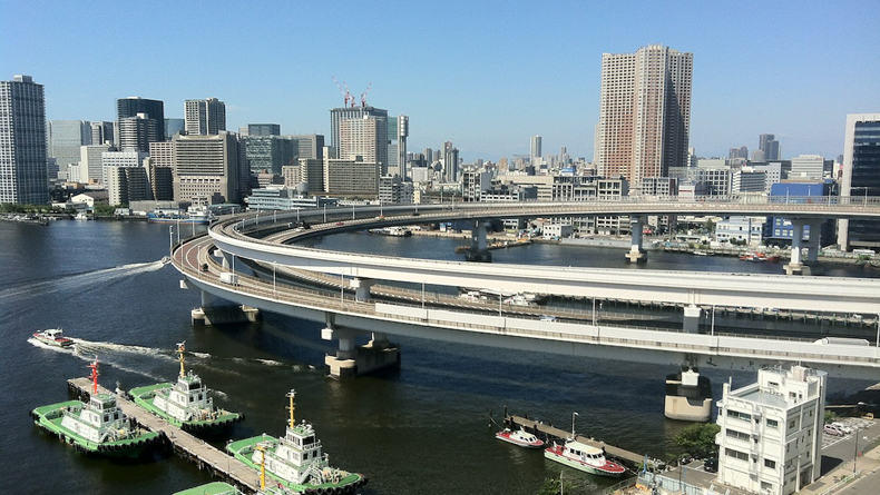
At only 798 meters in length, the Rainbow Bridge is not a great workout for the dedicated walker. However, it is an interesting and accessible wander for both locals and tourists alike.
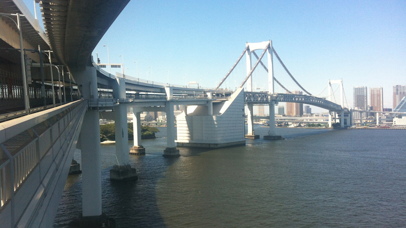
The bridge itself carries two decks, with the upper one being used for the Shuto Expressway Number 11. Underneath is a busy dual carriageway that is separated into north and southbound lanes by the Yurikamome transit line. The outer edges of this level of the bridge are the walking paths.
I took the Yurikamome from Shinbashi station to Shibaura Futo in order to begin my walk. It is a little depressing down at this end of town; wharves and receiving docks plastered with warning signs are eerily silent and seemingly empty of human life. At first I thought I’d gone the wrong way (be sure to leave the station via the east exit), but as there was no indication whatsoever of the direction I should take to the bridge I stumbled on for a further five minutes toward the massive on ramps of the Shuto.
Sure enough, there at the end of the street was a tatty sign with a faded rainbow painted on it and the bridge itself looming high above me. Panic about just how many steps it would take to get up to the walkway was soon dispelled by a young man in a uniform who kindly ushered me into the access building. An elevator takes you to the seventh floor and the entrance to the bridge.
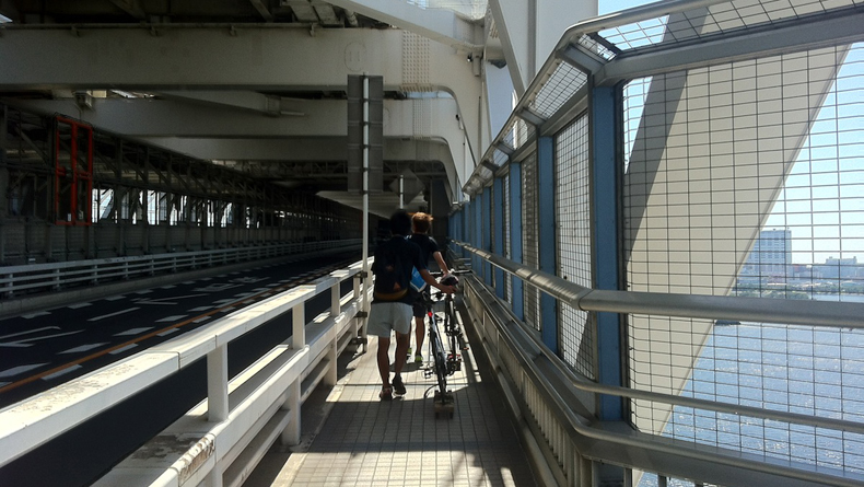
There are some rules for this short walk. You must leave for Odaiba via the south lane and only return via the north. Bike riders must avail themselves of a wooden ski not unlike a homemade skate board and attach it to the rear wheel of their bikes, rendering them unridable. They must yield to walkers without bikes, and they may not turn back halfway.
The first thing you notice about the walkway is the noise.
Highway traffic thunders above you, local trucks and cars whizz by you, and the Yurikamome hurtles regularly up and down the center of the bridge.
It really is loud. The second thing that gets your attention is the wind. It is brisk and constant. Hats are routinely blown away, so secure yours before leaving the access building. The path is paved and wide enough for two walkers abreast. The views are spectacular except for the caged effect of the metal safety netting over the handrails, but there are two viewing platforms along the way with fewer bars so that photos can be taken. The grand sweep of the vista more than makes up for this slight nuisance.
To the south, Tokyo Bay with its ceaseless marine traffic is splendid from up this high. Large ships and ferries leave clean white waves in their wake, and on a clear day the elusive Mt.Fuji can be spotted to the southwest (alas, not on the day I crossed). From the halfway point, the island of Odaiba and Daiba Park No. 3 Battery are visible. Odaiba, with its line of unmistakable architecture and sandy beachfront, is almost as iconic a landmark as the bridge itself. Daiba Park forms the top end of a small cove. Canon emplacements were put here in 1853 to protect Tokyo from the incursions of Commodore Perry and his Black Ships. Today it is a peaceful haven of lush green grass and walking paths.
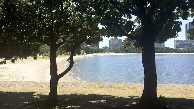
The descent from the bridge at the Odaiba end is a gently sloping ramp. The journey takes around thirty minutes. To the left as you descend are stairs that go under the bridge and over to the north walkway if you wish to return immediately. However this would be a mistake, as following the ramp down to its end puts you at the beachfront of Odaiba Marine Park (Odaiba Kaihin Koen).
I walked on a weekday and the beach and surrounding park were virtually deserted. The Japanese pines that line the island provide not only shade but also a visual window dressing for the view back toward the bridge. The historical gun emplacement can be walked, around and the beach with its sheltered bay is also an enjoyable place to add some kilometers to the walk.
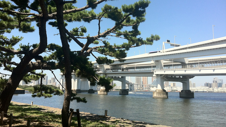
The Yurikamome station is only a few meters from here if you wish to return to Shimbashi directly by train. Otherwise it is back up the ramp and, remembering to take the north pathway, back across the bridge to the Shibaura side. The views are a little less spectacular on this side, but do include Tokyo Tower and the cityscape of downtown Tokyo. It is also hotter and less protected from the sun on this side of the bridge. My suggestion is that if you intend to only walk one way, make it from Shibaura to Odaiba.
Even with the noise, the heat and the wind, I found my Rainbow Bridge walk to be enjoyable and interesting. Adding the extra stroll at Odaiba Marine Park pushed this short walk up to around seven kilometers.
The Deets
When to go: The Rainbow Bridge walking path is open from 9 a.m. to 9 p.m. in the summer and from 10 a.m. to 6 p.m. in the winter. It is closed during inclement weather.
Map it out: To follow this walking route on a map, see below or click here to open in Google Maps.
More info: For additional information on Odaiba Marine Park, please click here.